Wednesday, November 24, 2010

Thanksgiving Day 2010

I'm thankful for so much in my life!

Waterfalls!

My new family! Just married!!!!

Reading... lots of reading! Atwood, and Chabon, and Ishiguro, oh my!

Vegan cookies!

My whole, extended family; in laws and all (even though this one isn't mine)!

New Girl Talk album that dropped this week!

Speedwell from my garden!

Caffeine... delicious, antioxidant loaded caffeine!

Thanks also to all my dear readers who have encouraged my adventure-sharing antics! Always keep hiking!

Friday, November 19, 2010

Formerly, Friday: Lake Conestee

This week's Formerly Friday post is certainly a former moment; early in 2010 my husband and I bought our first house prior to the wedding. We were beaming with excitement, but also overwhelmed. Combining two personalities worth of household items is never easy, and we had started to feel too caught up in the logistics of the move. A family day with Bruno and Dixie was desperately needed! How about a walk at the park?


Lake Conestee Nature Park is a secluded wetlands habitat along three miles of the Reedy River in the Donaldson area of Greenville. It's a simple set up; an exceptionally easy trail winds its way along, easily accessible from Mauldin Road or Henderson Avenue. The trail is a wooded boardwalk in some spots. This leisurely walk won't have you worried about tripping or having to bushwhack!


Like I said, the boardwalk makes for a very comfortable, easy going day. In April, the green was still attempting to burst through. It's such versatile wilderness, and it's mesmerizing how close to the downtown area you are!


The dogs enjoyed the exercise, and we enjoyed the ease of the day! Conestee is a simple morning out, one I recommend to all Greenville area folk.


Apologies for this wilderness walkabout not being very... wilderness! As the Holidays approach, I was just reminded of a special day with my husband and dogs. We're very lucky to have each other! I hope everyone's Thanksgiving is special, if you celebrate it; and if not, I hope that the month of November wraps up smoothly for you!

Sunday, November 14, 2010

Sulphur Springs Trail at Paris Mountain State Park

When Bruno, the eldest, stared longingly into my eyes Friday night, I naturally thought about how I'd miss him and his sister Dixie while I was at work on Saturday. Then I realized that if I felt bad now, I'd feel really bad leaving them for a day trip with my husband Sunday... so we changed our plans to include them; thus this post!

Steven and I couldn't rightly take our two dogs all the way to Chimney Rock State Park, as Dixie gets car sick. Nothing like a torturous hour and a half in a car to ruin a puppy's day! We settled on Paris Mountain, which we had attempted with our dogs about a year previous, with little success due to the summer temperatures. We ended up just doing the trail that runs around Lake Placid. It's maybe half a mile of easy, family friendly trail down at the public entrance of Paris Mountain State Park. Yesterday I decided on either the Brissy Ridge Trail or Sulphur Springs Trail for our family hike!

Paris Mountain State Park is very well marked in the Greenville area, both by street signs and it's entrance sign off of State Park Road. Paris Mountain is a rare monadnock, and the area surrounding it mere foothills compared to the actual mountains in the Mountain Bridge Wilderness Area, or Nantahala Forest. It's conveniently located to the Parker district of Greenville, and probably a twenty minute drive from any part of Greenville.

We entered the park, where you will be expected to pay $2.00 a person for the day; campers obviously pay a separate fee. We got our parking pass when we paid at the gate, Bruno and Dixie growling through the window at the poor gate attendant. For access to the white blazed Sulphur Springs Trail lower down the mountain, follow the paved road past the Lake Placid parking area, and continue up the road, past the final area for RV parking. The parking we used has a really nice picnic shelter available, and is labelled as Sulphur Springs parking. You can also continue up further for an easier walk along the yellow blazed Brissy Ridge Trail, as well as access the less challenging ridge line segment of Sulphur Springs trail, to connect to the blue blazed Firetower Spur, all by parking at the Buckhorn Gate.


We did park further down the mountain, at the parking area marked in the above map as the fourth available from the main entrance gate. We got our packs adjusted, double checked the dogs' leashes, and were on our way!

Paris Mountain State Park, as well as most other public parks, require that you keep your dog on a leash and under control. I feel it's my responsibility as a pet owner to make that perfectly clear, both for your own safety, that of your pet(s), and others.

The roughly three and a half mile Sulphur Springs Loop Trail starts out pretty easily from this parking area. We ambled along and let the dogs sniff to their hearts (or noses) content until we approached the neat tower adjacent to the dam of the Mountain Lake reservoir!


We stopped and took some pictures, then headed up the stone stairs to the right of the tower... and from there the climbing began!

Something about having to keep up with a healthy two year old dog's pace just made the elevation of this trail so much more intense than I was prepared for! The dog's were just so excited; they didn't always understand that their four legs could propel them up the rocks and roots of the trail a lot faster than our bodies! Having said that though, we thankfully got into a rhythm, and I may or may not have allowed Bruno's strength to help me up a little!

That first mile past the Mountain Lake reservoir and dam, and along the pretty creek is really the toughest of it; once Sulphur Springs begins to run as the bike trail, things are significantly more level, and you follow the ridge along some beautiful scenery.


We followed Sulphur Springs to the Firetower Trail spur, and went ahead to add the extra .4 miles of hiking to our day! It takes you to the highest point of elevation in the park, as is appropriate for the location of an old firetower!


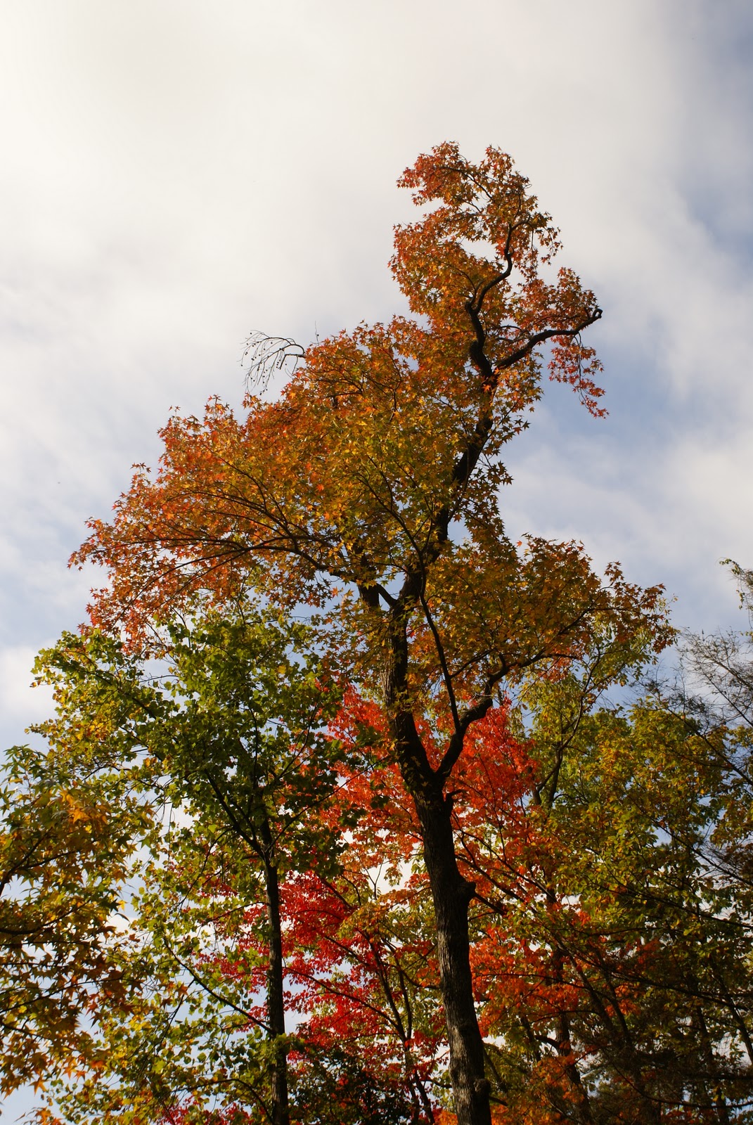
Once at the firetower, you do have to turn around and double back. We continued on our day along Sulphur Springs, and met with a lot more foot and bike traffic than I had expected along the ridge! It was a beautiful Carolina fall afternoon, and it's great to see people out with their families enjoying nature! Thank goodness this chunk of the trail along the ridge is so much less strenuous, with all that traffic! We got to relax and enjoy the amazing foliage!


You'll soon approach the Buckhorn Gate parking, where you can access the Brissy Ridge Trail as well. Had our tummies not been rumbling for lunch (sometimes, blueberries just aren't enough), we may have ventured out that way, too! Alas, we will just have to take Bruno and Dixie out for further adventures!

Sulphur Springs Trail from this point on is descending back down the mountain. This part was a bit tricky with our two eager dogs, as apparently two miles of moderate to strenuous hiking is not enough to curtail their energies! With a little patience and some friendly reminders, we did manage to keep Bruno and Dixie from taking us for a tumble down the somewhat steep trail! Good footing and safe pacing is always important.


Trail Recap for Sulphur Springs Loop Trail:
Sulphur Springs Trail (white blazes)
Firetower Trail (blue blazes)
Sulphur Springs Trail (white blazes)

All in all, Sulphur Springs is a great half day hike at Paris Mountain! It demanded just the right amount of energy from me; it had it's steep, strenuous moments, and it is certainly a trail that deserves your attention; even without the loss of traction due to all the fallen leaves, there are tree roots and rocks aplenty along the trail. We rounded our days' hiking to be at a little more than four miles, including the Firetower Trail spur. Always take water, and always enjoy yourself as you venture out! Thanks for reading, and please leave some feedback in the comments!

Stay tuned for the healthy habits post, as well as the latest Formerly, Friday! If anyone has ideas for great winter weather hikes in the area, do share!

Thursday, November 11, 2010

Road Trip #1: High Falls and Triple Falls at Dupont State Forest

It's the time of year when we're getting winter weather advisories for the northern part of the county... the mountains have had some snow fall, and we in the Foothills of the Blue Ridge are feeling the chill. So, sometimes a day hike isn't always in the cards.

My husband and I have, however, managed to wedge in some really special day trips into North Carolina as the weather cools, the first being about a month ago with my parents into Dupont State Forest. Dupont is located outside of Brevard, NC, on 276 on the way north out of the Mountain Bridge Wilderness Area towards Pisgah National Forest.

Dupont State Forest is home to some really majestic waterfalls, two of which we were able to visit with my folks that cloudy Sunday... with my parents' family dog: Sasha. Sasha is not your average dog. Indeed, she's comparable to Dee Dee in Dexter's Laboratory, complete with pink collar and leash. Sasha is part lab, and she is not going to be a hiking dog, as her energy level far exceeds that of the well trained dogs I've seen carrying their own packs across their backs, wandering after their master obediently along the trail without even a leash. Dupont State Forest's main attractions are accessible from really well maintained service roads and dirt roads for trails that are perfect for large groups and hyper puppies!

After a slight detour (we were almost to Asheville because apparently Dad's GPS decided to be hateful after Dad drove us north of Lyman because I naively assumed he remembered his way to Highway 11 and 276's intersection) that made our hour car trip two and a half hours, our baby Sasha was ready to go (literally and figuratively)! Mom took a potty break in the toilets available by the Buck Forest Road parking lot off Staton Road, while Sasha took hers in the grass next to the car. Dupont is well marked along 276, so just follow the signs once you're north of Caesar's Head State Park.

We headed down Buck Forest Road, which is a dirt service road that guests to the park can not take their own vehicles down. We caught sight of the covered bridge that goes over Little River at the head of High Falls. It's quite picturesque!


We snapped a few photos and let Sasha splash in the shallows of Little River, then it was up to the High Falls Trail that leads to a convenient overlook, which is very family friendly; however, the smaller, more narrow trail that heads down to the base of the falls is much more strenuous, and I can imagine incredibly dangerous after rainfall or if the weather has iced things over. There were some steps down part way, but mostly we scrambled down using tree and rhododendron roots as foot and hand holds; whilst poor Dad fought the war of the leash with excited Sasha! Steven helped my Mom down, as it is quite a balancing act! What a gentleman! Once down there though, we were blown away!


This was my shot from the base of High Falls, where we let Sasha jump head first into the water (lunatic dog) and all stopped to enjoy the enormity of this falls. It really is awe inspiring. Hopefully you'll be able to go see for yourself!


This was the view of High Falls and the covered bridge from the overlook; again, the overlook is probably the most appropriate vantage point for people with small kids, handicapped, or elderly folk with them, and let's admit it... that's an awesome sight no matter which way you look at it!

After enjoying High Falls, and convincing Sasha to get out of the kiddy pool/Little River, we headed further up into the park along the major trail that heads along the surprisingly calm Little River. Sometime in the future, though, I'll be sure to head west over the covered bridge along Buck Forest Road, where the meat of the Forest trails are and one could hike to Wintergreen Falls and Grassy Creek Falls as a good day hike.

The High Falls Trail has a pretty minor gain in elevation; it's a very easy trail though, as it's maintained for the large groups that flock to Triple Falls and High Falls. We approached Triple Falls from upstream, and reached the stairwell to access the base of the middle section of Triple Falls; and that stairwell was not a joke. All the way down we were thinking, "Climbing these stairs back up will be awesome!" The only one of our party not phased was of course Sasha!


Who blames the sweet puppy, when these views are at the end of your leash! She knows what's important!


This photo just captures the middle and upper section of Triple Falls, where the stairwell sets you down amidst this lovely feature. There are usually tons of people all over Triple Falls; it's pretty easy to climb along all three sections of the falls, for those fit and careful enough to attempt it. My husband and I climbed to the top, while Mom, Dad, and Sasha just took the opportunity to take it all in!


This is a close up of the upper falls. There are innumerable beautiful angles to see this sight from!


This last shot is of the lower falls, which we didn't climb down to as the rain was coming. We barely had time to climb back up the stairwell and snap a shot from the Triple Falls overview before the downpour began, but here is that photo!


We headed back to the Buck Forest Road parking area by taking the Triple Falls Trail from the Triple Falls overview, to cut off some ground and make a little better time; not that it helped us when the rain started. What began as a few drops became a typical Carolina afternoon downpour! By the time we got back to the car twenty minutes later, we all smelled like wet puppy; certainly couldn't blame it all on Sasha, though!

Another point of interest in Dupont State Forest is Hooker Falls, and you can easily access this falls from another short trail from the Triple Falls area, but we got rained out! It just gives us an excuse to head back up to the beautiful, well maintained area of Dupont State Forest sometime in the spring! Bring a sandwich, as it is about two miles of easy hiking from the Buck Forest Road parking area to High and Triple Falls. Elevation isn't really an issue, and the overlooks are very accessible for those who don't consider themselves hikers or climbers. We were lucky that we were in such shape that we could all go to the base of the falls we visited and get closer up the grandeur of it all! I highly recommend Dupont to those who find themselves near Brevard, as a pit stop on your way to Asheville or Hendersonville! Check out this link for a really simple map of the trails that lead to the three most popular falls in the park! Waterfalls of Dupont State Forest

I dedicate this post to my Mom, who braved a day at a State Forest with her crazies... because Mom knows better than any one that Sasha is in fact the most sane of us all! I love you, Mom!


To my readers and solitary follower (thanks, Dad!), I haven't forgotten my nerdy post about healthy eating and hiking as new lifestyle choices for myself. Life is getting very hectic, and I'm trying to keep a balance, and my sanity! Thanks for all of your patience, prayers, and feedback. Hopefully my husband and I will have a chance this weekend to visit Chimney Rock State Park, and I will have a new Road Trip post, in lieu of a day hike with my Dad. I'll keep doing my best to make interesting, informative posts.

Friday, November 5, 2010

Formerly, Friday: Falls Creek Falls

It's sad that it's taken me nearly two weeks to make this post. Between a week with the flu and the inevitable onslaught of pre-Holiday madness, my life in retail has stepped it up a notch! What crushes me, though, is not the duration of time between my last posts, but the duration of time between my last hikes. It's going to be a struggle, as well, for me to find the time to go camping with my Dad. This breaks my heart, because my adventures with Dad were to be the anecdotes that fed this blog. Rest assured that ideas, past trips, and day hikes will keep  flowing; and hopefully, I can build up some comments and feedback to keep the cogs turning! That being said, don't be shy!

My best friend and Dad went with me on this trail a couple of Sundays ago. The weather was great; a little cool in the morning, with only a couple of clouds to bar the sun from shining through the leaves that were beginning to turn along the trail. We started at about 10:00 am. Falls Creek Falls Trail is a really rewarding, challenge of a trail! The Jones Gap State Park trailhead is accessible at the Palmetto Bible Camp. It was a bit interesting following the signs for the Bible Camp to get there, as you're headed in an odd direction away from the main access of the State Park.


That being said, once you find the trailhead by following the road that leads directly through the Bible Camp area, you are met with considerable warning about the strenuous nature of this trail. It's an area notorious for rain washouts, and the trail sometimes involves a fair amount of scrambling and hand holds. Bring a ton of water, as always, and wear good shoes with ankle support. This was a trail that made me wish I had all ready picked up walking sticks!

We didn't see any one out on this trail until the very end; it's a quiet, relaxing day, but the isolation of this trail makes it that much more important to have a first aid kit and to be prepared for an emergency. It can be very lonely up there.


You dive straight in to the elevation gain; this purple blazed trail is not a joke! Any one familiar with the Dismal Trail in the Mountain Bridge Wilderness Area will forgive my newfound habit of grumbling about purple blazes! My calves were burning, and we were barely a third of the way into this! It's fun, though; there's tons of huge boulders along the trail, and great large rocks hanging overhead.


The further up the trail you get, the more you see the evidence of washouts. I will use the word "scramble" lightly. We two girls were, at times, on all fours trying to get around some of the switchbacks, while my Dad flew up ahead of us and delighted in turning around to giggle at our clumsy attempts! What can I say... we are truly novices! The trail follows up the ridge amongst thick plant life, and the closer you get to the waterfall, the steeper and more thick the trail gets. It is very rocky on the approach to the falls, and dangerous because the spray from the falls keeps everything slick and damp. The view, yet again, though, is spectacular.


We snacked and enjoyed the view, because, what else should you do? It was fantastic. The colors of the trees around the falls framed it perfectly; a beautiful autumn day. We climbed out for better views, thankful for shoes with good traction.


Again, be careful of the slippery rocks. We went further up from the right side of the falls along a really rough trail; this part could be dangerous, as it is so washed out and overgrown. The upper falls are equally beautiful, and provide a pretty amazing look out of the area!


We were probably up at the falls for about an hour, taking time with both parts of the falls and snacking on peanuts (thanks for the provisions, Dad).


If you felt it was a bit intense climbing up, it's probably worse headed back down. Scrambling is the word I use lightly! Go slow, and take your time on the climb down. It's really easy to slip or loose your footing. We were back to the trailhead by about noon; it's a quick hike, but well worth the effort. This trail isn't for the faint of heart, nor the faint of lungs! We got lucky with our timing; the fresh fall foliage hadn't faded brown and made the trees look sparse. We had a great morning, and I hope any body who has the time can make a day out of enjoying the beautiful Fallls Creek Falls!


Thanks to Elizabeth and Dad for joining me on this particular trail!