
Thursday, October 28, 2010
Sneezing, and coughing, and flu... oh my!
Admittedly, I don't know if I have the flu. I've been feeling pretty awful all week, thus the lack of updates on the Falls Creek Falls. I'm hoping to be more articulate in the next few days, but as of now, it's like all the balloon head and foggy cliches combined. Hopefully I can reward any anticipation for future posts sooner rather than later!

Friday, October 22, 2010
Formerly, Friday: Raven Cliff Falls, SC
My favorite hike so far was with my dad; the Raven Cliff Falls loop at Caesar's Head State Park in South Carolina. It's a nearly nine mile loop that serves as an incredible sampling of the versatility to be found in the scenery at Caesar's Head!
Dad and I parked near the trailhead where you can access the Coldspring Branch Trail and Tom Miller Trail for access to the Jones Gap Trail! The sign is a bit odd, though; the sign on the side of the parking lot that you take for the Raven Cliff Falls trail to the overlook says Foothills Trail.

The Natureland Trust Trail continues west as the Foothills Trail; as always, keep your eyes open for your blazes!
 Head out on the red blazed Raven Cliff Falls Trail (#11) for a pretty moderate hike that has some stellar views of the Blue Ridge! If you choose to continue along the red blazes to the overlook for Raven Cliff Falls about a mile further. If you're interested in the loop we did, take the Gum Gap Trail (blue blazes, #13)! This is where the trail gets fun! There's a moderate stretch for the first chunk of the Gum Gap Trail, but the closer you get to the water, the more you have to scramble downwards towards the creek that feeds Raven Cliff Falls. There was some moderate bushwhacking; nothing serious, just some intensely overgrown rhododendrons! We followed along the Matthews Creek and passed some pretty cascades!

Gum Gap Trail meets the Natureland Trust Trail (pink blazes, #14) and the Foothills trail at the suspension bridge that goes over the top of Raven Cliff Falls. Dad and I took the pink blazes for our loop... and this is where you really have to scramble down the mountain, but not after some spectacular views!
 As I said, after the suspension bridge, be prepared to use all fours to wedge your way down the rocky trail that goes down into the cliffs. This part of the trail seriously slowed us down, and really tested my leg strength. As always, bring plenty of water. At this point, Dad and I were throwing back handfuls of trail mix to help us keep at our best!
The Natureland Trust Trail is a beautiful trail... there are so many huge boulders, and once you get down into the cliffs, your mind should be thoroughly blown!

Honestly, this was one of my favorite moments from this loop. I just was not expecting such an impressive sight! I'd love one day to hike the entire Natureland Trust Trail, and spend more time down in woods like this spot! Unfortunately for us, though, our last mile on the Natureland Trust Trail was only the beginning of our work! Before we moved on to the next segment of our hike, we had the pleasure of climbing across a pretty stream by two tow lines tied to trees about four feet above the surface of the water... FUN!

It was a ton of fun once I got over my slight fear... note the death grip! The key was to slide your feet, not step with them, and alternate moving your feet, then your hands [thanks for sharing this piece of information with me before I attempted it and landed in the stream, Dad(and yes, he's typically capable of such tomfoolery)]. I don't necessarily think this tactic of getting across the water is necessary; the water isn't that deep and certainly wasn't moving very quickly while we were at this spot. I suppose it's mostly a convenience factor, as not every one plans on wearing water sport socks. Next up was the Dismal Trail!
The Dismal Trail (purple blazes, #12) is quite dismal indeed! All of that elevation that we'd lost headed down to the suspension bridge, and then even further down into the cliffs (over 1000 feet) we had to make up: in half a mile.Wow. Yap. Dismal.

While Dad and I struggled up this part of our loop, Dad noticed some rocks to our left that looked out over the park; and behold! Dad found an awesome overlook to the Falls minus the crowd at the official overlook!

We had some water, one by one snuck behind some bushes to take care of business, ate some more trail mix, and headed back to the Raven Cliff Trail to hike the nearly two miles back to the parking lot; after such a convenient yet private overlook, who needs to go to the public spot?!
I've said it before, but I'll say it again. This trail was my favorite, and mostly just because it was with Dad! We had so much to talk about! For Dad, hiking is a familial association, as his father taught him to respect the outdoors. There is a lot of peace for Dad in being on a hike or camping, and I'm grateful to have been welcomed into the fold!
Aside from me walking straight into the mud on the trail while Dad walks around into the bushes to avoid the mud, he also had to point out that the "bear tracks" were in fact dog tracks. Yap. We talked about how much water you took out on the trail with you sometimes depended on the temperature; this came up as a way to lecture me about how it wasn't always a grand idea for me to fill my water bottles on the rocks of waterfalls, like I have been known to do on hikes with my husband. Thus my new camel bag for my pack, and Dad's ownership of a water filter! We've also discussed picking up walking sticks for me; I have a weak ankle from an incident I had when I was a kid, and that ankle still turns dangerously on a dime when I'm climbing.
All in all, this fabulous day spent with Dad back in August is truly what got my brain so fixated on camping, backpacking, and hiking with my Dad. I'm glad he's so excited to take me along, as I know I have so much to learn!
Trail Recap to get the most out of the fantastic Raven Cliff Falls area:
Raven Cliff Falls Trail (red blazes, #11)
Gum Gap Trail (blue blazes, #13)
Natureland Trust Trail (pink blazes, #14)
Dismal Trail (purple blazes, #12)
Raven Cliff Falls Trail (red blazes, #11)
Well, Sunday's hike to Falls Creek Falls is still a go, but that may be our last one for a few weeks. Work schedules are not cooperating. On the flip side, though, my husband and I will have a chance to take a little day trip to some waterfall hubs that involve far less intensive hiking! I'll try to post again soon; either a recap of Falls Creek Falls, or a post I've been pondering for a few days about healthy eating habits while on and off the trail. This could be interesting, as while I don't claim to be a nutrition whiz at all, I seem to be in the best shape of my life, without really trying... could be an interesting conversation!
Dad and I parked near the trailhead where you can access the Coldspring Branch Trail and Tom Miller Trail for access to the Jones Gap Trail! The sign is a bit odd, though; the sign on the side of the parking lot that you take for the Raven Cliff Falls trail to the overlook says Foothills Trail.
The Natureland Trust Trail continues west as the Foothills Trail; as always, keep your eyes open for your blazes!
Gum Gap Trail meets the Natureland Trust Trail (pink blazes, #14) and the Foothills trail at the suspension bridge that goes over the top of Raven Cliff Falls. Dad and I took the pink blazes for our loop... and this is where you really have to scramble down the mountain, but not after some spectacular views!
The Natureland Trust Trail is a beautiful trail... there are so many huge boulders, and once you get down into the cliffs, your mind should be thoroughly blown!
Honestly, this was one of my favorite moments from this loop. I just was not expecting such an impressive sight! I'd love one day to hike the entire Natureland Trust Trail, and spend more time down in woods like this spot! Unfortunately for us, though, our last mile on the Natureland Trust Trail was only the beginning of our work! Before we moved on to the next segment of our hike, we had the pleasure of climbing across a pretty stream by two tow lines tied to trees about four feet above the surface of the water... FUN!
It was a ton of fun once I got over my slight fear... note the death grip! The key was to slide your feet, not step with them, and alternate moving your feet, then your hands [thanks for sharing this piece of information with me before I attempted it and landed in the stream, Dad(and yes, he's typically capable of such tomfoolery)]. I don't necessarily think this tactic of getting across the water is necessary; the water isn't that deep and certainly wasn't moving very quickly while we were at this spot. I suppose it's mostly a convenience factor, as not every one plans on wearing water sport socks. Next up was the Dismal Trail!
The Dismal Trail (purple blazes, #12) is quite dismal indeed! All of that elevation that we'd lost headed down to the suspension bridge, and then even further down into the cliffs (over 1000 feet) we had to make up: in half a mile.Wow. Yap. Dismal.
While Dad and I struggled up this part of our loop, Dad noticed some rocks to our left that looked out over the park; and behold! Dad found an awesome overlook to the Falls minus the crowd at the official overlook!
We had some water, one by one snuck behind some bushes to take care of business, ate some more trail mix, and headed back to the Raven Cliff Trail to hike the nearly two miles back to the parking lot; after such a convenient yet private overlook, who needs to go to the public spot?!
I've said it before, but I'll say it again. This trail was my favorite, and mostly just because it was with Dad! We had so much to talk about! For Dad, hiking is a familial association, as his father taught him to respect the outdoors. There is a lot of peace for Dad in being on a hike or camping, and I'm grateful to have been welcomed into the fold!
Aside from me walking straight into the mud on the trail while Dad walks around into the bushes to avoid the mud, he also had to point out that the "bear tracks" were in fact dog tracks. Yap. We talked about how much water you took out on the trail with you sometimes depended on the temperature; this came up as a way to lecture me about how it wasn't always a grand idea for me to fill my water bottles on the rocks of waterfalls, like I have been known to do on hikes with my husband. Thus my new camel bag for my pack, and Dad's ownership of a water filter! We've also discussed picking up walking sticks for me; I have a weak ankle from an incident I had when I was a kid, and that ankle still turns dangerously on a dime when I'm climbing.
All in all, this fabulous day spent with Dad back in August is truly what got my brain so fixated on camping, backpacking, and hiking with my Dad. I'm glad he's so excited to take me along, as I know I have so much to learn!
Trail Recap to get the most out of the fantastic Raven Cliff Falls area:
Raven Cliff Falls Trail (red blazes, #11)
Gum Gap Trail (blue blazes, #13)
Natureland Trust Trail (pink blazes, #14)
Dismal Trail (purple blazes, #12)
Raven Cliff Falls Trail (red blazes, #11)
Well, Sunday's hike to Falls Creek Falls is still a go, but that may be our last one for a few weeks. Work schedules are not cooperating. On the flip side, though, my husband and I will have a chance to take a little day trip to some waterfall hubs that involve far less intensive hiking! I'll try to post again soon; either a recap of Falls Creek Falls, or a post I've been pondering for a few days about healthy eating habits while on and off the trail. This could be interesting, as while I don't claim to be a nutrition whiz at all, I seem to be in the best shape of my life, without really trying... could be an interesting conversation!
Tuesday, October 19, 2010
Appalachian Outfitters
My Dad's sense of responsibility towards his kids hasn't lessened even though we're both in our twenties. Indeed, he insists on our picking up all of the necessities we need for a safe hike/backpacking adventure, because his own experiences have proven that better gear can make the difference. He's a stalwart supporter of a Greenville, SC local business that any local hiker should know of: Appalachian Outfitters.
I've been to other outfitters in the area, and they either don't have the service or the know-how that the people at App. have. It's book prices, but you have the peace of mind of knowing that the person helping you has been out on the trail, under the stars, dependent on their gear to keep them safe. Plus, they aren't jerks. They are so friendly, and eager to share their experiences!
I ordered my pack about three weeks ago, and picked it up about a week later! App Outfitters had to order a small women's pack for me, as they don't usually have them in stock. See what I mean about having to special order tiny people supplies? I ended up getting an Osprey Ariel! It's an awesome pack that has a hip belt that is made with clay, and is shaped and cooked in an oven to be perfectly formed for your body for better support! My pack is huge; I could quite easily fit my 85 lb. dog in there!
Also, as an early gift for the upcoming Holidays, my parents invested in some awesome North Face Sable hiking boots for me! Early gift, as my Dad is getting impatient with me going on hikes for four or more miles in my $20 Walmart shoes! My new hiking boots have great ankle support; I can't wait to try them out this weekend!
All of the gear I'm excited to try out was purchased at Appalachian Outfitters. Dad has had some amazing experiences with an online outfitter, Backcountry. I'll make sure to add these vendors to my link list, for future connectivity!
My Dad and I are taking my best friend in the world up to the Mountain Bridge Wilderness Area to hike to Falls Creek Falls on Sunday! I'm also hoping that Dad and I won't have any impediments to another hike on Tuesday; impediments like body aches! Hopefully my sister will have the all clear to go backpacking with us in November, and there will be an over-night trip to hike the entire Jones Gap Trail! Should be a pretty amazing month of fabulous foliage and family time!
Thursday, October 14, 2010
Resources for the Road...
There are two books I've been referring to as guides to the most appropriate spots and trails for my purposes; day hikes with my dad versus with my husband tend to vary significantly in intensity, although maybe not in the directions you'd assume! I have to know the elevation gains, because after our experience at Rainbow Falls, Steven flat out told me that he doesn't feel it's safe on his knee to take on that much of a climb. With my dad, the sky is the limit; so long as we can make it back to the car before dark!
 Safety is our top priority when we're out. I've got my first aid kit, plenty of water, and I always know my blaze colors by heart if I'm doing a hike that involves multiple trails, etc. I also usually search the web for someone's personal account of what I'm considering and trail maps; I want to know as many details as I can before I commit. These two books have been amazing!
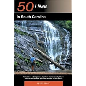
50 Hikes in South Carolina: Walks, Hikes & Backpacking Trips from the Lowcountry Shores to the Midlands to the Mountains & Rivers of the Upstate
by Johnny Molloy
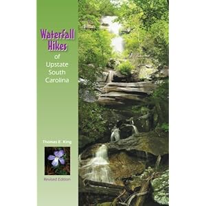
Waterfall Hikes of Upstate South Carolina
by Thomas E. King
I bought King's book first, just on a whim. It's clear listings of waterfalls in Oconee, Pickens, and Greenville County was just what I needed to tell me the distance from trailheads or parking to the falls, whether the falls is located on private property, what areas are watefall hubs and make for good day trips, and all sorts of information about the waterfalls! I love this book! The only downfall of this book is that while it does have simple maps of the individual counties it's discussing, with major roads and locations of the waterfalls pictured, there are not any maps of trails included; which is why I bought Molloy's book!
Molloy's book has the trail maps for each hike it discusses, as well as a really cool grid listing the trails, their difficulty, whether or not their are falls or historic sites along the trails, and their mileage! It's been an awesome supplement to King's book for me, and I hope to get more usage out of it next spring and summer for some weekend trips outside of my Upstate home zone!
Both of these books can be purchased at the links I provided to Amazon.
This weekend I'll be enjoying some much needed family time and outings with friends! I'm planning on taking my husband, sister, and her love to Pleasant Ridge County Park for the easily accessible falls Sunday afternoon, so there won't be much to report early next week. As always, I'm interested in suggestions for great day hikes, even if it may be another week or so until I get to do a day hike again (tragedy). Share your experiences out on the trail with Microbear! They can't be as embarrassing as screaming because of a squirrel!
Safety is our top priority when we're out. I've got my first aid kit, plenty of water, and I always know my blaze colors by heart if I'm doing a hike that involves multiple trails, etc. I also usually search the web for someone's personal account of what I'm considering and trail maps; I want to know as many details as I can before I commit. These two books have been amazing!50 Hikes in South Carolina: Walks, Hikes & Backpacking Trips from the Lowcountry Shores to the Midlands to the Mountains & Rivers of the Upstate
by Johnny Molloy
Waterfall Hikes of Upstate South Carolina
by Thomas E. King
I bought King's book first, just on a whim. It's clear listings of waterfalls in Oconee, Pickens, and Greenville County was just what I needed to tell me the distance from trailheads or parking to the falls, whether the falls is located on private property, what areas are watefall hubs and make for good day trips, and all sorts of information about the waterfalls! I love this book! The only downfall of this book is that while it does have simple maps of the individual counties it's discussing, with major roads and locations of the waterfalls pictured, there are not any maps of trails included; which is why I bought Molloy's book!
Molloy's book has the trail maps for each hike it discusses, as well as a really cool grid listing the trails, their difficulty, whether or not their are falls or historic sites along the trails, and their mileage! It's been an awesome supplement to King's book for me, and I hope to get more usage out of it next spring and summer for some weekend trips outside of my Upstate home zone!
Both of these books can be purchased at the links I provided to Amazon.
This weekend I'll be enjoying some much needed family time and outings with friends! I'm planning on taking my husband, sister, and her love to Pleasant Ridge County Park for the easily accessible falls Sunday afternoon, so there won't be much to report early next week. As always, I'm interested in suggestions for great day hikes, even if it may be another week or so until I get to do a day hike again (tragedy). Share your experiences out on the trail with Microbear! They can't be as embarrassing as screaming because of a squirrel!
Monday, October 11, 2010
Rainbow Falls
My husband and I had planned on going to Falls Creek Falls yesterday, but I messed up the directions and told him to just go ahead and park in the Jones Gap State Park lot. What's the difference, right? The hike to Rainbow Falls was said to be roughly the same distance and difficulty, based on my reading and surfing the web.
When you park, you can head out on the trail that leaves on the car exit end of the parking lot and do a simple loop around a pond of the Jones Gap salmon hatchery. Or, head more directly into the park by heading out on the end of the parking lot that you entered into, which is a road that leads to RV and handicap parking closer to the visitor center.
It was about 10:30 in the morning when we started out at the trailhead, and we headed out on the Jones Gap Trail (#1, blue blazes) for about .7 miles. This part of the trail is really easy, and follows a beautiful segment of the Middle Saluda River.
 This trail meets with the Rainbow Falls trail (#4, red blazes) and the work begins! There are a couple of bridges passing over creeks that feed the Saluda from further up the mountain; after the final bridge, you go through an awesome stair cut out from a massive boulder, and start the gain in elevation.


 This segment was pretty thick with shrubbery and fall flowers, so the trail felt pretty slim. Be careful, as there are lots of rocks in the ground, and the trail hugs the slope tightly. Again, the trail winds its way back into the mountain, and the boulder and cliffs begin to dominate the side of the mountain!

The rest of the trail leads into the granite walls of Rainbow Falls! There is plenty of shade, and the cool breeze we had on that day made us feel worlds better after the strenuous hike. Let me stress something, now: I hadn't intended on hiking this trail. Indeed, it wasn't really a priority. None of the pictures I had seen in books and online had really endeared me to it.
I was totally wrong.
 Pictures just do not do it justice. The 80-100 foot drop of water from Cox Camp Creek may look like a trickle in photos, but it's a fierce fall that crashes onto rocks and cascades further into the rocky gorge for about a thousand feet, over tiny shoals, through and under rocks, and finally down the mountain. The entire acre or so is just beautiful. We ate our lunch and I took as many photos as I could. Again, please do not underestimate the beauty and value of this falls, and hike!


 The colors of the foliage made this hike really special for us. I'd imagine all of the azaleas and plant life would be amazing in the spring, too! The walk back down the trail after we spent about an hour at Rainbow Falls took about another hour... as opposed to the hour and a half it took us to get up there! This trail and the falls are incredible, though. The fun of climbing through boulders, over planks for bridges, as well as the beauty of the views of both the falls and the Blue Ridge can't be beat.
My husband did comment that all of the stairs started to take a toll on his knees, especially on the hike back down; keep things like that in mind if you have weak ankles, knees, etc. I suppose there are so many stairs to aid your climb, so that you don't feel like you're going to have to scramble up. I don't know that I have an opinion either way, but obviously my husband does!
Overall, the trail is very clear up the mountain, and blazes are pretty frequent. I stress the importance of taking plenty of water and some grub, as this trail took us about two and a half hours round trip. The hike rounds out to roughly 2.4 miles. It's a beautiful time to have at Jones Gap, and I highly recommend it!
Trail Recap to the glorious Rainbow Falls area:
Jones Gap Trail (blue blazes, #1)
Rainbow Falls Trail (red blazes, #4)
return back along Jones Gap Trail (blue blazes, #1)
Sometime in the next week I will try to post some information on two SC hiking books I've been using. Also, I haven't forgotten to add a picture of my new pack; I was just so excited to post about a fresh hike! If anyone has suggestions or comments, please feel free to use them! If you've hiked in the area, share your story! Trail anecdotes can be pretty great!
When you park, you can head out on the trail that leaves on the car exit end of the parking lot and do a simple loop around a pond of the Jones Gap salmon hatchery. Or, head more directly into the park by heading out on the end of the parking lot that you entered into, which is a road that leads to RV and handicap parking closer to the visitor center.
It was about 10:30 in the morning when we started out at the trailhead, and we headed out on the Jones Gap Trail (#1, blue blazes) for about .7 miles. This part of the trail is really easy, and follows a beautiful segment of the Middle Saluda River.


There are a lot of stairs built into the trail (dare I say, a few too many) and a lot twists up the mountain. You gain 1000 ft in 1.6 miles. It can be pretty hard work, so absolutely make sure you bring plenty of water and some food. Steven and I had PB&Js in my pack for our arrival at the falls with granola bars! There is a lot of water, as the trail does follow a stream on some of your cycles around the mountain, so please beware of snakes; a guy we passed warned us of one, but we didn't come across any ourselves.We did see a pretty cute lizard; or rather, Steven spotted it and spent about ten minutes trying to point it out to my blind ol' eyeballs! I started thinking he was making it up around the same time it poked its little head out and I finally caught a glimpse!
We got to a part of the trail that leads you along a steep ridge with amazing views out into the Blue Ridge!


The rest of the trail leads into the granite walls of Rainbow Falls! There is plenty of shade, and the cool breeze we had on that day made us feel worlds better after the strenuous hike. Let me stress something, now: I hadn't intended on hiking this trail. Indeed, it wasn't really a priority. None of the pictures I had seen in books and online had really endeared me to it.
I was totally wrong.


My husband did comment that all of the stairs started to take a toll on his knees, especially on the hike back down; keep things like that in mind if you have weak ankles, knees, etc. I suppose there are so many stairs to aid your climb, so that you don't feel like you're going to have to scramble up. I don't know that I have an opinion either way, but obviously my husband does!
Overall, the trail is very clear up the mountain, and blazes are pretty frequent. I stress the importance of taking plenty of water and some grub, as this trail took us about two and a half hours round trip. The hike rounds out to roughly 2.4 miles. It's a beautiful time to have at Jones Gap, and I highly recommend it!
Trail Recap to the glorious Rainbow Falls area:
Jones Gap Trail (blue blazes, #1)
Rainbow Falls Trail (red blazes, #4)
return back along Jones Gap Trail (blue blazes, #1)
Sometime in the next week I will try to post some information on two SC hiking books I've been using. Also, I haven't forgotten to add a picture of my new pack; I was just so excited to post about a fresh hike! If anyone has suggestions or comments, please feel free to use them! If you've hiked in the area, share your story! Trail anecdotes can be pretty great!
Friday, October 8, 2010
Formerly, Friday...
While I attempt to find some semblance of a routine with posting, hiking, etc, I will try to have a fortnightly Friday post that will catch up our hiking history, as well as give me a sense of fulfillment (seeming as only having two posts feels silly)! Next week, I'll be sure to put together a full report on our Sunday activities!
On our honeymoon, one of the hikes my husband and I attempted was the Lovers Leap Trail on the AT outside of Hot Springs, TN! It was a little drizzly that day, and I in my infinite wisdom had only packed prissy clothes for honeymooning in... typical of me.

 We met the trail at the Silvermine Trailhead along the French Broad River. The first few switchbacks were pretty moderate, then elevation definitely picked up. You can follow the white AT blazes to get to the rocky outcroppings, and the views are worth the quick gain in elevation! It's over one and a half miles, and can be credited as the birthplace of my husband and I's favorite mutual phrase of endearment: "trail buddy."

 Hot Springs is a great historic town, with natural springs that provide locals, tourists, and AT hikers alike with serious R&R. The springs are located amongst the ruins of a late nineteenth century resort; turns out Hot Springs was where the lucky few went to "take the air." Our honeymoon was our second visit out there and honestly, minus the obvious romantic associations the place has for me, we absolutely love the community. Pisgah Forest and segments of the AT make for great day hikes!
On our honeymoon, one of the hikes my husband and I attempted was the Lovers Leap Trail on the AT outside of Hot Springs, TN! It was a little drizzly that day, and I in my infinite wisdom had only packed prissy clothes for honeymooning in... typical of me.
Tuesday, October 5, 2010
Starting Point: Mountain Bridge Wilderness Area
I consider the trails of the Mountain Bridge Wilderness Area in Greenville County, SC to be like the agility courses in boot camp. It's a wake up call that my soul sometimes needs.
I work a forty hour week (of course!), am newly married, and in the first year of being a home owner. As of course all of us can feel every now and again, I just need to feel like there is something I can conquer. No matter the loss of balance, the stumbles, loss of breathe, I leave the trail feeling like I've done something important. If I can make it back to the car, I feel pretty groovy!
"Getting to the top is optional. Getting down is mandatory." -- Ed Viesturs (No Shortcuts to the Top: Climbing the World's 14 Highest Peaks)

Two of the best hikes I've ever been a part of have been in the Mountain Bridge Wilderness Area, and I hope to share a little of those experiences in further detail in the future, mishaps and embarrassments included! I take a ton of photographs while I'm hiking, so I can better document these adventures.
This next weekend will most likely be taking me back to the Bridge Wilderness, for Falls Creek Falls. The plan is to take Trail #31, then see if my husband feels up to #4 to also see Rainbow Falls, as we'll be in the area! It's also possible that my pack should arrive this week... and in that case, I will be posting a photo of it! Beyond that, I need to get back to work on reading a library book due back next week!
Thanks for stopping by, and if any one has any trail recommendations for the Upstate area of SC, please feel free to share them!
I work a forty hour week (of course!), am newly married, and in the first year of being a home owner. As of course all of us can feel every now and again, I just need to feel like there is something I can conquer. No matter the loss of balance, the stumbles, loss of breathe, I leave the trail feeling like I've done something important. If I can make it back to the car, I feel pretty groovy!
"Getting to the top is optional. Getting down is mandatory." -- Ed Viesturs (No Shortcuts to the Top: Climbing the World's 14 Highest Peaks)
Two of the best hikes I've ever been a part of have been in the Mountain Bridge Wilderness Area, and I hope to share a little of those experiences in further detail in the future, mishaps and embarrassments included! I take a ton of photographs while I'm hiking, so I can better document these adventures.
This next weekend will most likely be taking me back to the Bridge Wilderness, for Falls Creek Falls. The plan is to take Trail #31, then see if my husband feels up to #4 to also see Rainbow Falls, as we'll be in the area! It's also possible that my pack should arrive this week... and in that case, I will be posting a photo of it! Beyond that, I need to get back to work on reading a library book due back next week!
Thanks for stopping by, and if any one has any trail recommendations for the Upstate area of SC, please feel free to share them!
Monday, October 4, 2010
An Old Adventure of A New Microbear...
Weeks ago, as an unsuspecting curiosity develops into a passion, a naive rookie hiker goes off into the Alaskan wilderness... and so begins our journey...
My husband and I happened across the Dewey Lake trail system while visiting Skagway, Alaska on our first cruise together. After three days stuffing ourselves with rich food and lounging on deck chairs, a hike sounded perfect.
Of course, anyone else would be more sensible than to go off hiking in Alaska... with little to no real hiking experience or trail map in hand. A couple day hikes in the Piedmont of South Carolina with either my husband or dad in the month approaching this cruise really don't prepare one for the dramatic ecological differences; ie, the habitats of black bears, grizzlies, Kodiak bears, and (much further north, thank God) even polar bears. Having said that, though, it should be noted that said day hikes had instilled within me a new enthusiasm and excitement for the outdoors; the exercise of hiking, the unique challenges presented, the peace of traveling the depths of the wilderness!
The first half mile was made up of fierce switchbacks, picking up elevation so fast that before long I was taking bird's eye view shots of downtown Skagway. Once we approached Dewey Lake, the trails diverged and we decided to head towards a waterfall (that I won't bother naming as we never made it, curse that scheduled excursion). We were about two miles into our hike when we started seeing evidence of bears.

Previous to this trail, I probably would have squealed with glee over the thought of seeing tracks of any animal. Most inexperienced hikers dont' respect the reality of a bear sighting; and we were definitely of that vein.
I snapped a photo of the bear tracks in the mud, and wondered if the shredded bark at my eye level was evidence of bears. A little further on, the woods grow thick and dark and of course, I start to panic a bit inwardly.
"Steven, I think we should keep our voices down and be a bit more weary."
Silence. "OK. I'm watchin'."
I start almost tip-toeing along the trail, craning my neck to see further into the brush. "No, seriously... we need to keep our eyes and ears wide open so that we don't get caught unawares."
Of course, this is the moment that shuffling sounds in the leaves next to the tree I was approaching turn into a rather violent sweep of motion from the ground onto a branch, and behold!
I scream like a girl as the fierce little squirrel squeaks at me in terror from the idiot Carolinian who thought his movement amongst the underbrush had been... well... a bear. Yap.
Much to my dismay, I can't quite shake this anecdote. Steven spent another hour and a half on the trail with me, squeaking randomly like a squirrel, and when we were sharing photos of the cruise with my family, of course the story came out.
My sister's response? Google "Alaskan squirrels" and fall into hysterics when a picture of Theodore from the Chipmunks comes up.
My mom wisely kept quiet. She commonly does worse when out in the woods... or just fifty feet distance from a grounded toilet.
My dad, however, had to take it one step closer... and come up with Microbear. Now, he has not so far referred to me as Microbear; but for lack of any other more creative or poetic devices with which to title what I hope will become a public journal of my future trail excursions, it seems fitting.
I'm a little over five foot, petite, and I hate that word. I had to special order a pack small enough. Physically, hiking can be intense for me. I'm very much a rookie. I have a lot to learn. This is very much about a passion for the outdoors, and a need to accomplish something different. My dad and I talk about doing the Appalachian Trail. I have no idea if that's realistic, but I know if my dad wants to try it, I'd say let's go! It's gotten to me, and I'd like to share that, record it, remember.
So, this is Microbear; I'll say it with a smile now. The girl that screamed and ran from a squirrel is going to brave the outdoors!
My husband and I happened across the Dewey Lake trail system while visiting Skagway, Alaska on our first cruise together. After three days stuffing ourselves with rich food and lounging on deck chairs, a hike sounded perfect.
Of course, anyone else would be more sensible than to go off hiking in Alaska... with little to no real hiking experience or trail map in hand. A couple day hikes in the Piedmont of South Carolina with either my husband or dad in the month approaching this cruise really don't prepare one for the dramatic ecological differences; ie, the habitats of black bears, grizzlies, Kodiak bears, and (much further north, thank God) even polar bears. Having said that, though, it should be noted that said day hikes had instilled within me a new enthusiasm and excitement for the outdoors; the exercise of hiking, the unique challenges presented, the peace of traveling the depths of the wilderness!
The first half mile was made up of fierce switchbacks, picking up elevation so fast that before long I was taking bird's eye view shots of downtown Skagway. Once we approached Dewey Lake, the trails diverged and we decided to head towards a waterfall (that I won't bother naming as we never made it, curse that scheduled excursion). We were about two miles into our hike when we started seeing evidence of bears.
Previous to this trail, I probably would have squealed with glee over the thought of seeing tracks of any animal. Most inexperienced hikers dont' respect the reality of a bear sighting; and we were definitely of that vein.
I snapped a photo of the bear tracks in the mud, and wondered if the shredded bark at my eye level was evidence of bears. A little further on, the woods grow thick and dark and of course, I start to panic a bit inwardly.
"Steven, I think we should keep our voices down and be a bit more weary."
Silence. "OK. I'm watchin'."
I start almost tip-toeing along the trail, craning my neck to see further into the brush. "No, seriously... we need to keep our eyes and ears wide open so that we don't get caught unawares."
Of course, this is the moment that shuffling sounds in the leaves next to the tree I was approaching turn into a rather violent sweep of motion from the ground onto a branch, and behold!
I scream like a girl as the fierce little squirrel squeaks at me in terror from the idiot Carolinian who thought his movement amongst the underbrush had been... well... a bear. Yap.
---
Much to my dismay, I can't quite shake this anecdote. Steven spent another hour and a half on the trail with me, squeaking randomly like a squirrel, and when we were sharing photos of the cruise with my family, of course the story came out.
My sister's response? Google "Alaskan squirrels" and fall into hysterics when a picture of Theodore from the Chipmunks comes up.
My mom wisely kept quiet. She commonly does worse when out in the woods... or just fifty feet distance from a grounded toilet.
My dad, however, had to take it one step closer... and come up with Microbear. Now, he has not so far referred to me as Microbear; but for lack of any other more creative or poetic devices with which to title what I hope will become a public journal of my future trail excursions, it seems fitting.
I'm a little over five foot, petite, and I hate that word. I had to special order a pack small enough. Physically, hiking can be intense for me. I'm very much a rookie. I have a lot to learn. This is very much about a passion for the outdoors, and a need to accomplish something different. My dad and I talk about doing the Appalachian Trail. I have no idea if that's realistic, but I know if my dad wants to try it, I'd say let's go! It's gotten to me, and I'd like to share that, record it, remember.
So, this is Microbear; I'll say it with a smile now. The girl that screamed and ran from a squirrel is going to brave the outdoors!
Subscribe to:
Posts (Atom)